ES473/573 Environmental Geology


Class Syllabus (Adobe Acrobat Format)

Spring 2009 Syllabus
  • Updated Class Schedule - April 25, 20009

    2008-2009 Finals Schedule

    Bulletin Board **Check Here for Class News and Events**

    Final Grades - Posted June 15, 2009 - Good Work! Have a Good Summer!


    Spring 2009 Course Materials

    Links to Week 1 Activities
  • Class Notes: Introduction to Environmental Geology
  • Introductory Video Exercise
  • DOGAMI (1999) - Special Paper 32 Mitigating Geologic Hazards in Oregon
  • Example Article Summary

    Links to Week 2 Activities
  • Introduction to Earthquakes and Seismology
  • Earthquakes and Seismology Video Exercise
  • Overview of Earthquake Hazards in Oregon
  • Summary Notes - Wang (2000) Presentation on Oregon Seismic Hazards

    Seismic Hazards Lab Exercise
  • Seismic Hazards Lab Figures (Exercise 6)
  • Seismic Hazards Lab Figure 2.17 (Ex. 6)

  • Primer on Determining Earthquake Recurrence Intervals

    Slide Show: Tectonics Overview
    Slide Show: Seismic Hazards

    Links to Week 3 Activities
  • Volcanic Hazards of the Pacific Northwest
  • Volcanic Hazards of Mt. Hood, Oregon
  • Volcanic Hazards Lab Exercise
  • Volcanic Hazards Lab Figures (Exercise 4)

    Slide Show: Volcanic Hazards

    Links to Week 4 Activities
    Click Here for 2009 AEG Student Night - Poster Titles
  • Click Here for 2009 AEG Student Night - Poster Images (*.ppt)

  • Mass Wasting and Landslide Hazards
  • Case Study: Co-Seismic Landslides in Japan
  • Overview of Rapidly Moving Landlides and Debris Flows in Oregon

    Landslide Hazards Lab Exercise
  • Landslide Hazards Lab Figures
  • Refresher on Reading Topo Maps and Drawing Profiles

    Slide Show: Mass Wasting Hazards

    Links to Week 5 Activities
    LIDAR Seminar Summary Notes: OSU, April 28, 2009 (Faux-Watershed Sciences)
  • Overview of LIDAR Topographic Survey Methods (Hill et al., 2000)
  • LIDAR Mapping Fact Sheet
  • LIDAR Applications for Ecosystem Studies (Lefsky et al., 2002)
  • LIDAR Applications for Landslide Analysis (Glenn et al., 2006)
  • LIDAR Applications for Landslide Analysis Under Forest Cover (Eekhaut et al., 2006)

  • Slide Show: Introduction to LIDAR Mapping Technology

  • Oregon LIDAR Consortium Status Maps (May 2009)

    Overview of Flood Hazards
  • Slide Show: Rivers and Flood Hazards
  • Animation: Hydrologic Cycle Animation (NASA)

    Links to Week 6 Activities
    Midterm Portfolio Instructions - Due Thurs. May 7
    Midterm Study Guide Updated 5/2/09
    Spring 2009 Showcase Abstracts (Final Document Submitted May 4, 2009)

  • Introduction to Landfill Technology
  • Overview of Landfill Terms / Concepts
  • Figures to Accompany Landfill Notes
  • Coffin Butte Field Trip Summary Notes (2000)
  • Coffin Butte Field Trip Summary Notes (2001)

  • Coffin Butte Landfill Field Guide

    Links to Week 7 Activities
    Introduction to Groundwater

  • Groundwater Video Summary Questions
  • Figures to Accompany Groundwater Notes
  • Drilling / Field Techniques

    Slide Show: Introduction to Groundwater

    Lab Exericise: Geology, Planning, and Landfill Design
  • Lab Figures - Geology, Planning, and Landfill Design

    Lab Exercise: Groundwater Flow Problem Set

    Links to Week 8 Activities
    May 20 Seminar Reading: Goldfinger et al., 2008, Linkage Between Cascadia Earthquakes and San Andreas Seismicity

    Case Study: Dallas, OR - Aquifer Storage and Recovery (ASR) Hydrogeologic Feasibility Study (2005)
    Slide Show: Regional Hydrogeology of Willamette Valley

  • Field Guide to Regional Hydrogeology of Mid-Willamette Valley
  • Guidelines to Hydrogeologic Reports in the State of Oregon

    Lab - Ground Water Introduction Part II

    Links to Week 9 Activities
    Spring 2009 Showcase Abstracts (Drafts and Edits)

    Geologic Framework of Western Oregon and Washington
    Surficial Geology of Western Oregon and Washington
    Subduction Processes in Cascadia
    Intraplate Faulting in Cascadia Subduction Zone
    Historic Seismicity and Neotectonics in Western Oregon
    Ground Shaking Hazards
    Co-Seismic Landslides
    Liquefaction Hazards
    Seismic Hazard Reduction
    Earthquake Preparedness
    Seismic Hazards in Seattle Area
    Seismic Hazards in Tacoma Area
    Seismic Hazards in Portland Area
    Seismic Hazards in Mid-Willamette Valley
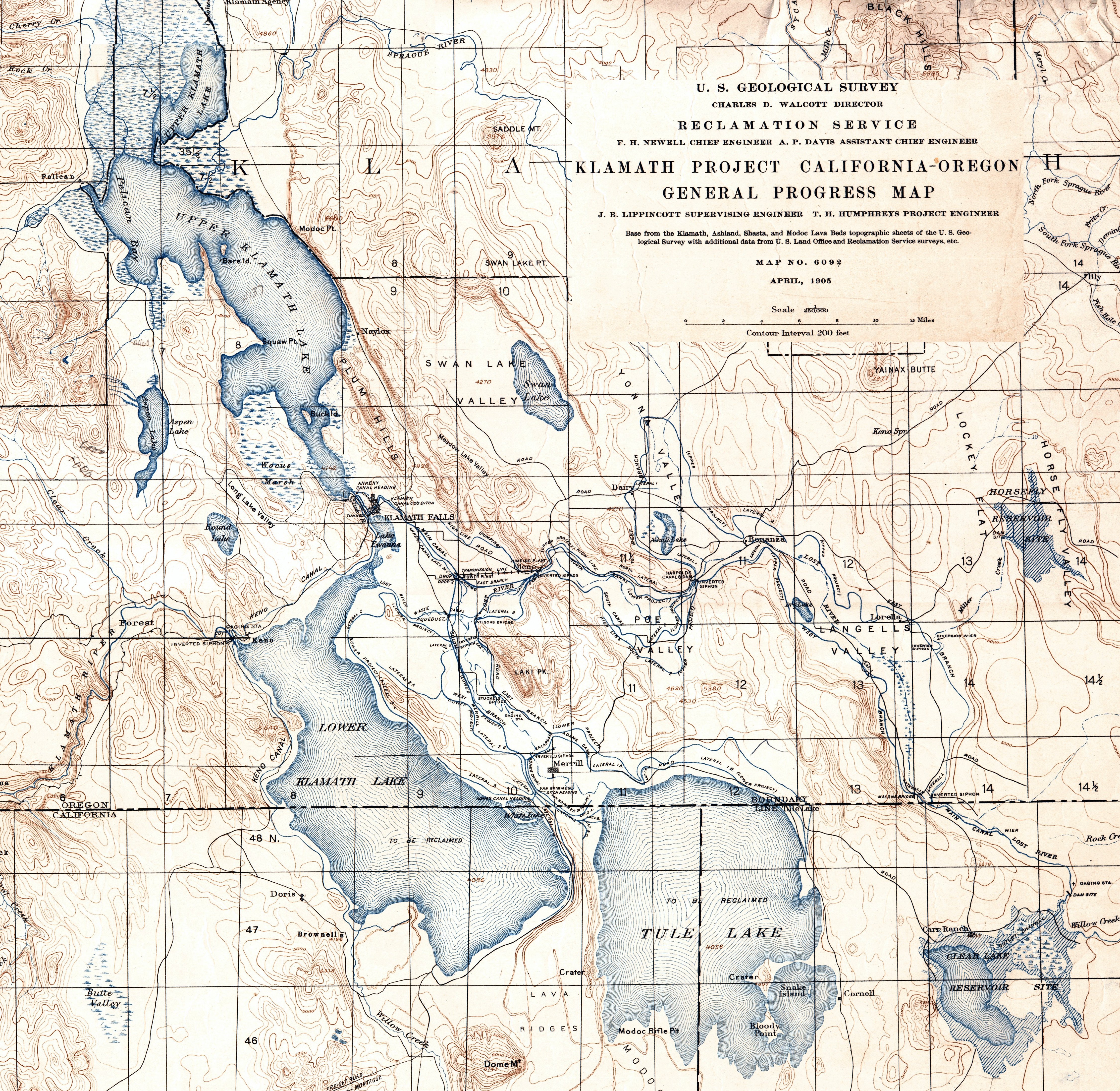
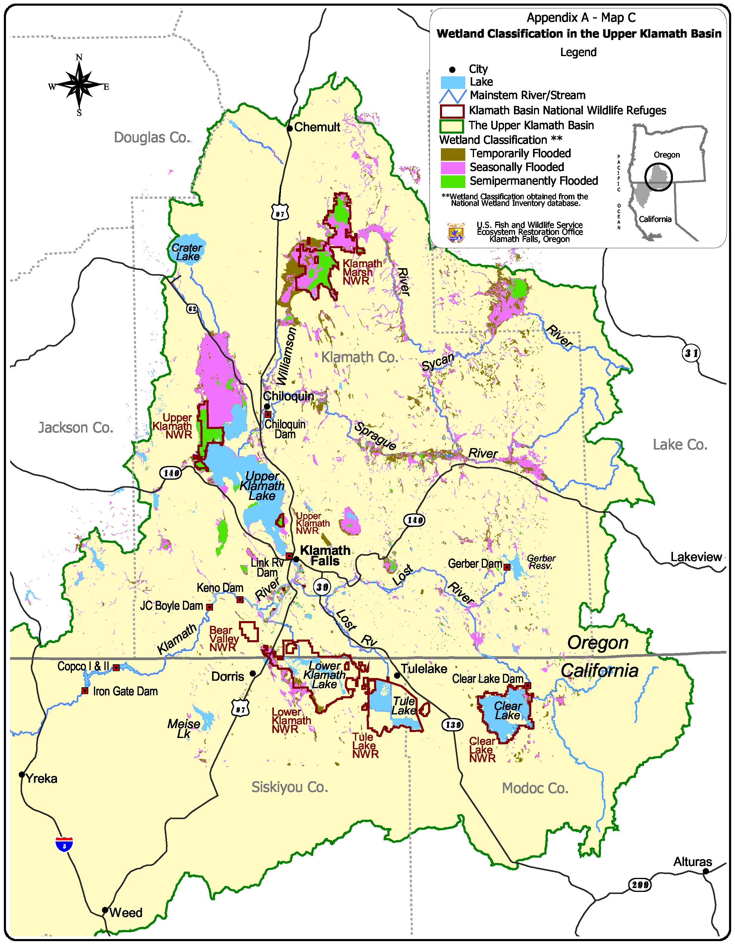
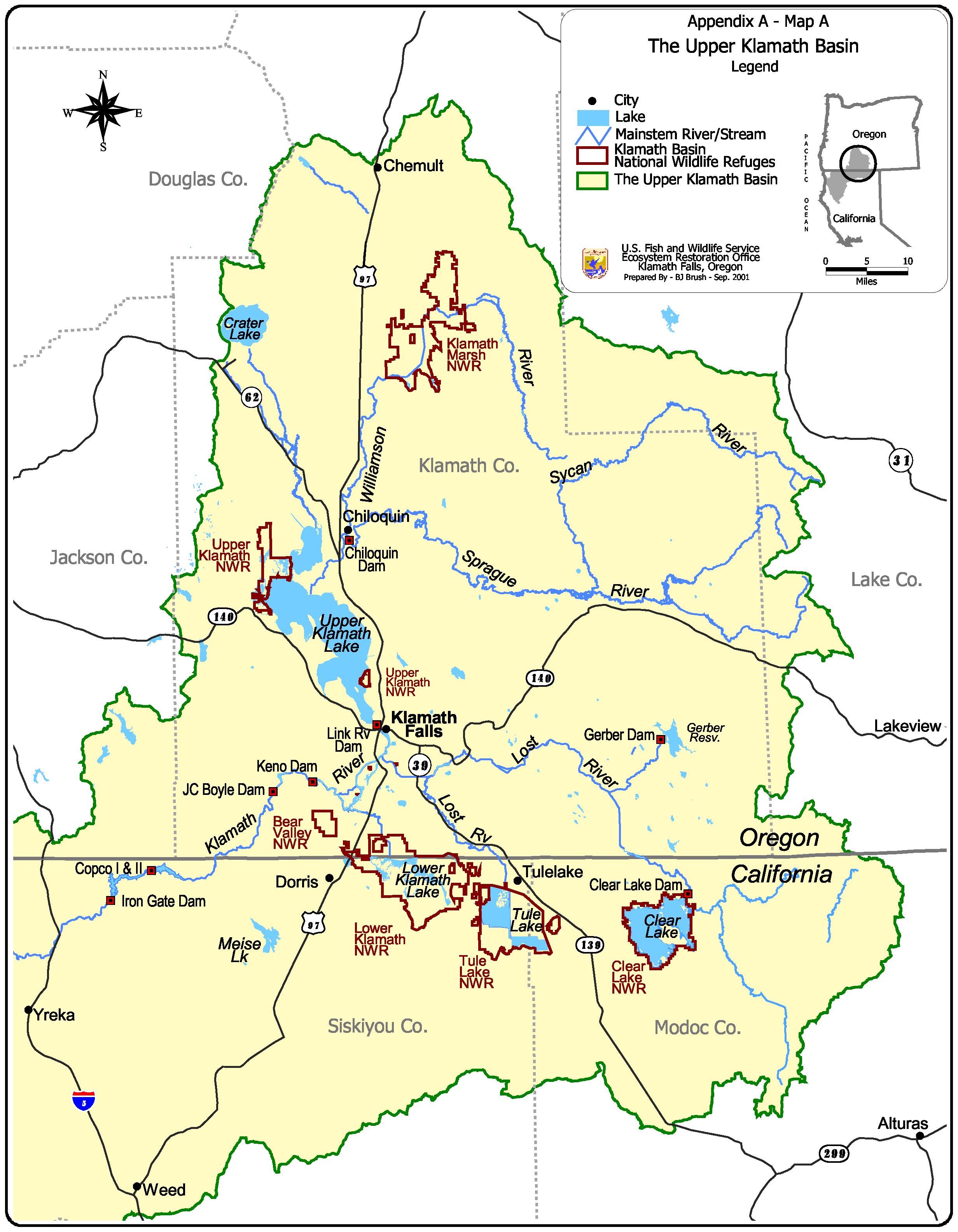
    Seismic Hazards in Klamath Falls Area

    Links to Week 10 Activities
    Summary Reading - Hydrogeologic Framework of Southern Willamette Valley
    Summary Reading - Environmental Setting of Willamette Valley
    Summary Reading - Groundwater Quality in Southern Willamette Valley

    Review Questions - Hydrogeology of the Willamette Valley (MS word *.doc)


    Class Note Archive

    The class notes are organized according to their order of occurrence throughout the term. They are available in Adobe Acrobat Reader (PDF) Format. Acrobat Reader is invoked as a plug-in within the web browser environment. It is available on most machines at WOU. Acrobat Reader can be downloaded for free by returning to Taylor's Home Page

    Exam study guides will be included as the term progresses. Please check future postings as exam time approaches

    Introductory Notes

    Plate Tectonics / Rocks and Minerals

    Overview of Oregon Geology

    Oregon Geologic Hazards Management

    Seismic Hazards

    Related Paleoseismology Reports for the Pacific Northwest

    Volcanic Hazards

    Flood Hazards

    River Restoration / Dams / Fluvial Habitat Issues

    Mass Wasting / Debris Flow Hazards

    Water Resources and Pollution

  • Intro to Water and Hydrologic Cycle
  • Water Pollution Issues
  • Reading: Urich and Wentz (1999) Environmental Setting of the Willamette Basin

    Groundwater

    Groundwater Contamination and Remediation

    Coastal Hazards and Development Issues

    Global Climate Change

    Landfill / Solid Waste Management

    Engineering and Applied Geology

    Field Trip Notes 1: Overview of Tyee Landscape/Central Coast Range Geology (Taylor Summary)
    Field Trip Notes 2: ODOT Hwy 20 Pioneer Mountain-Eddyville Project (Squire Summary)
    Link to ODOT Hwy 20 Pioneer Mountain-Eddyville Project Website

    Preparing Applied Geology Reports

    LIDAR Techniques and Methodology

    LIDAR Seminar Summary Notes: OSU, April 28, 2009 (Faux-Watershed Sciences)
  • Overview of LIDAR Topographic Survey Methods (Hill et al., 2000)
  • LIDAR Mapping Fact Sheet
  • LIDAR Applications for Ecosystem Studies (Lefsky et al., 2002)
  • LIDAR Applications for Landslide Analysis (Glenn et al., 2006)
  • LIDAR Applications for Landslide Analysis Under Forest Cover (Eekhaut et al., 2006)

  • Oregon LIDAR Consortium Status Maps (May 2009)


    Class Slide Shows

    Tectonics Overview
    Seismic Hazards
    Volcanic Hazards
    Hydrologic Cycle / Global Water Budget
  • Hydrologic Cycle Animation (NASA)
    Rivers and Flood Hazards
    Mass Wasting Hazards

    Introduction to LIDAR Mapping Technology

    Introduction to Groundwater
    Water Pollution Overview
    Regional Hydrogeology of Willamette Valley
    Overview of Groundwater Contamination and Remediation
    Case Study: Regional Controls Nitrate Contamination in the Willamette Aquifer
    Case Studies: Groundwater Contamination and Remediation in the Willamette Valley

    Field Trip Guides

  • Field Guide to Geology and Geomorphology of the Mid-Willamette Valley
  • Field Guide to Environmental Geology of Monmouth-Independence Area
  • Coffin Butte Landfill Field Guide

    Field Trip - Association of Engineering Geologists Student Night - PSU, April 21, 2009
  • Click Here for 2009 AEG Student Night - Poster Titles
  • Click Here for 2009 AEG Student Night - Poster Images

    Field Trip - Association of Engineering Geologists Student Night - PSU, April 15, 2008
  • Click Here for 2008 AEG Student Night - Poster Titles
  • Click Here for 2008 AEG Student Poster Abstracts


    Spring 2009 PNW Seismic Hazards Project Resources

    Spring 2009 Showcase Abstracts (Final Document)
  • Spring 2009 Showcase Abstracts (Drafts and Edits)

    Spring 2009 Academic Showcase Project - Topics
    2009 Academic Showcase Seismic Hazards Reading Assignments by Topic and Student (April 21, 2009)
    Click Here for Downloadable Articles and Papers on Seismic Hazards in the Pacific Northwest
    Spring 2009 Academic Showcase Project - Topics

    General Resources and Project Guides

    Guide to Writing Scientific Abstracts

    Guide to Preparing Abstracts
    Guide to Preparing Scientific Posters
    Reference Citation Method (use for all text/graphics)

    Powerpoint poster template (Portrait 32 x 40 inches) - rt-click-saveas-save to your folder
    Powerpoint poster template (Landscape 40 x 32 inches) - rt-click-saveas-save to your folder
  • Alternative Poster Template (Research Poster 36 x 48 A.ppt)
  • Alternative Poster Template (Research Poster 36 x 48 B.ppt)
  • Alternative Poster Template (Research Poster 36 x 48 C.ppt)
  • Alternative Poster Template (Research Poster 36 x 48 F.ppt)
  • Alternative Poster Template (Research Poster 48 x 30 D.ppt)
  • Alternative Poster Template (Research Poster 48 x 30 A.ppt)

    Poster Scoring Guide for Peer Reviews

    References and Reading Materials on Seismic Hazards (Spring 2009)

    Click Here for Downloadable Articles and Papers


    Student Willamette Basin Posters (Spring 2008)

    Earth Science in Context: Land Use and Watershed Function in the Willamette Basin (Dr. Taylor - Session Overview)
    Tectonic Framework of the Willamette Valley (Josh Troyer)
    Physiographic Framework of the Willamette Lowland (Ben Shivers)
    Quaternary Geology and Geomorphology of the Willamette Basin (Ian Macnab)
    Environmental Setting and Landuse in the Willamette Basin (Tanja Aas)
    Present-Day Climate and Vegetation (Laura Stallard)
    Quaternary Climate and Vegetation History(Bobby Kelso)
    Groundwater Hydrology of the Willamette Valley (Brittnie Andrew)
    Landuse History and Hydrologic Alteration of the Upper Willamette (Heather Hintz)
    Geomorphic Hazards (Kristin Mooney)
    Landslide Processes in the Central Oregon Coast Range (Matt Buche)
    Landslide and Debris Flow Occurrence in Headwaters of the Willamette (Donnie Kasper)
    Ecological Response to Geomorphic Disturbance (Emily Hardy)
    Vegetative Response to Landscape Disturbance (Shawn Coreson)
    Geomorphic Response to Forest Practice (RC Mock)
    Influence of Timber Harvest on Sediment Transport in the Willamette Basin (Levi Hogan)
    Effects of Forest Roads and on Hillslope Hydrology and Sediment Production (Allison McGonagle)
    Dams and Gravel Mining - Effects on Riparian Zone (Alicia Thompson)
    River Restoration in the Willamette Basin (Patrick Stephenson)

    Student Project Abstracts (May 5, 2008)

    Click Here for Final Abstracts (*.pdf acrobat format)
    Click Here for Final Abstracts (*.doc MSword format)

    Class Assignment / Reference Notes

    Spring 2008 - Willamette Basin Project Assignment and Student Team List (Updated April 14, 2008)
    Spring 2008 - Willamette Basin Project Reference List (Draft 2 April 14, 2008)

    Guide to Preparing Abstracts
    Guide to Preparing Scientific Posters

    Powerpoint poster template (Portrait 32 x 40 inches) - rt-click-saveas-save to your folder
    Powerpoint poster template (Landscape 40 x 32 inches) - rt-click-saveas-save to your folder

    Reference Citation Method (use for all text/graphics)

    Poster Scoring Guide for Peer Reviews

    References (Spring 2008)

    Click Here for Downloadable Articles and Papers

    Spring 2008 Class Project Topics and References Lists are Now Available - See Links Below!

    Spring 2008 - Showcase Project Assignment and Student Team List (Updated April 14)
    Spring 2008 - Showcase Project Reference List (Updated April 14)
    Click Here for Downloadable Showcase Project Articles and Papers

    Spring 2006 Klamath Basin Project Resources

    Klamath Student Posters (Spring 2006)

    Physiography and General Setting of Klamath Basin (Renae Burger)
    Regional Geology (Wagner)
    Groundwater of Klamath Basin (Downing)
    Surface Water Hydrology of Klamath Basin (Pirot)
    Water Quality Issues in the Klamath Basin (Katie Noll)
    History of Dam Building in the Klamath Basin (Andrew)
    Landuse History of the Klamath Basin (Dan Hidy)
    Fisheries of the Klamath Basin (Cody Hoehna)
    Water Laws and Policies Governing the Klamath Basin (Renae Burger)
    Summary of Environmental Issues in the Klamath Basin (Trever Redding)

    Class Assignment / Reference Notes

    Klamath poster project assignment and topic list

    Klamath Poster - Reference Citation Method (for all text/graphics)

    Preliminary Klamath Basin Reference List
    Guide to Preparing Scientific Posters

    Powerpoint poster template (Portrait 36 x 48 inches) - rt-click-saveas-save to your folder
    Powerpoint poster template (Landscape 36 x 48 inches) - rt-click-saveas-save to your folder

    Klamath Poster - Reference Citation Method (use for all text/graphics)

    Web Links

    USGS Klamath Basin Project Reference Database
    Klamath Falls Bureau of Reclamation Office Website
    USGS Klamath Basin Project Web Site
    Oregon Water Resources Dept. - Klamath Basin Adjudication Links
    Oregon Water Resources Dept. - Water Law
    Klamath Basin Crisis Homepage
    Oregon Natural Resources Council (Klamath Issues / Links)

    Reports and Publications

    National Geographic, 2008, Klamath Basin: Issues and Overview
    Gannett et al., 2007, Groundwater Hydrology of the Upper Klamath Basin
    Braunworth et al, 2003 - OSU Extension Report - Overview of Water Allocation Issues in Klamath
    Oregon Dept. of Environmental Quality 2005 - Channel Morphology and Classifcation of Klamath
    Oregon Dept. of Environmental Quality 2005 - Land Cover and Land Use Classification of Klamath
    Oregon Dept. of Environmental Quality 2005 - Basin Hydrology of Klamath
    Oregon Dept. of Environmental Quality 2005 - Water Quality and TMDL Limits
    Dileanis et al., 1995 - Water Quality of Klamath - 1990-1992 Study
    Gates, 2000 - Groundwater hydrology for select areas of Klamath Basin
    Gonthier, 1985 - Aquifer Units of Eastern Oregon
    Hamilton et al., 2004 - Fish History and Dams in Klamath Basin
    Oregon Special Commision: Review of Management Activities in Klamath Basin
    Lynch and Risley, 2003 - USGS Hydrologic Conditions of 2002 Fish Kill in Klamath Basin
    McFarland, 1983 - Aquifer Units of Western Oregon / Overview
    Nathenson, 1992 - Water Balance for Crater Lake region, Klamath Basin
    Newcomb and Hart, 1958 - Preliminary Report on Groundwater Resources in Klamath Basin
    Risley and Caenen, 1999 - Upper Klamath Lak Basin Nutrient Loading Study (good background info)
    U.S. Fish and Wildlife, 2000 - Environmental Assessment of Klamath Basin
    U.S. Geological Survey, 2005 - Water Budget and Hydrologic Overview of Klamath Basin

    Maps-Figures-Images

    Klamath Basin Project Historical Map - 1902 (*.jpg image)
    Klamath Basin Wetlands Map (*.jpg image)
    Upper Klamath Basin Location Map (*.jpg image)

    Class and Lab Exercises

    Introductory Video Exercise

    Unit Conversion Tables

    Introduction to Quantitative Methods in Geology

    Introduction to Engineering Geology Problem Set
  • Background Reading: Problems in Rock Properties

    Slope Stability Problem Set
  • Background Reading: Slope Stability

    Flood Hazards Lab
  • Surface Water Equation List
  • Surface Water Data (Excel)

    Introduction to Surfer Software Package Groundwater Flow Problem Set

    Mountain Fir Part A - Well Log Interpretation

    Mountain Fir Part B - Site Project Click here to join a global climate model experiment!

    Luckiamute Watershed Assessment Assignment

    Lab Manual Exercises

  • Refresher on Reading Topo Maps and Drawing Profiles

  • Volcanic Hazards
  • Volcanic Hazards Lab Figures (Exercise 4)

  • Mt. St. Helens Case Study

    Seismic Hazards
  • Seismic Hazards Lab Figures (Exercise 6)

  • Loma Prieta Case Study

    Landslide Hazards
  • Landslide Hazards Lab Figures
  • Refresher on Reading Topo Maps and Drawing Profiles

  • Ground Water Introduction
  • Ground Water Contamination
  • Water Quality
  • Geology and Planning - Landfill Design

    Surface Water Hydrology Techniques

  • Beeson, 1968, Comparison of Flood Frequency Methods Used by Federal Agencies

  • Tips and Guidelines for Conducting Streamflow Analysis

  • Overview of Flood Frequency Analysis

  • Overview of Annual Streamflow Analysis
  • Tutorial on Annual Streamflow Anlysis
  • Annual Tutorial Data (*.xls)

  • Tutorial on Daily Streamflow Analysis
  • Tutorial on Instantaneous Streamflow Analysis
  • Instantaneous Tutorial Data (*.xls)

  • Overview of Flow Duration Analysis
  • Tutorial on Flow Duration Analysis
  • Flow Duration Tutorial Data (*.xls)


    Lab / Quiz Answer Keys

    Intro to Quantitative Methods Key
    Intro to Rock Properties Lab Key

    Slope Stability / Mass Wasting Lab Key
    Groundwater Flow Problems Key
    Well Log Exercise Key
    Mountain Fir Project Key


    Writing and Presentation Guides

    Guidelines for Geowriting (New Spring 2009!)

    General Guide to Technical Writing for Earth Science Students
    A General Template for Compiling a Lab Exercise Portfolio
    Example Article Summary
    Guide to Preparing Scientific Posters

    Spring 2006 Writing Assignments and Due Dates

    Study Guides

    Midterm Study Guide Updated 5/2/09

    Final Exam Study Guide - Final Thurs. June 11, 12-2 PM

    Final Lab Portfolio Checklist - June 2, 2009