A couple Websites to explore ESRI's
Community Mapping Project (6000 schools and more than 30,000 students
are collaborating in this effort) http://www.ersi.com/industries/k-12/atlas
Look at the terrain in an area and map out a route for a marathon.
Or a bike path. Or ski runs.
Compare and analyze two different running routes. Which route
is better for building endurance? Which is better for building
speed?
Have students map our a "best path" for a recreational
trip. They could map a bike path, a roller-blading path, a walking/jogging
path, or any other outdoor activity that would take a path.
Have students map out a route to run on. Have them find approximately
how many miles they were going to run. Map the hazards they
might encounter, sites they would run by, and ways to remain
safe.
Health
Map polluted areas in a community. Overlay disease incidence
data. Is there a relationship?
Map different places in a community where one can get healthy
foods.
Look for resources in a community to use for exercise or to
stay physically fit including tracks, basketball courts, fitness
gyms, baseball fields, parks, etc. Make a full size map of the
town and input the street names and where the resources are
located on these specific streets.
Map out local agencies that are available to help our with
teen pregnancy, and see how the placement to those agencies
relates to the ratio of teen pregnancies.
Study park and recreation sites in towns and calculate how
much focus is given outdoor activities.
Literature
Construct a map of the setting for a novel you are reading.
Look for clues in the book about terrain, landmarks, landscape,
etc. and create a database of setting details.
Give the students a blank U.S. or world map and then plot
where all of the books and their authors are from within a certain
theme or unit, such as a unit on WWII literature. This project
would show them how universal different themes in literature
are, but also how these different regions treat the same subject.
Language Arts
Map out your ideal town and then write a story about what
happens in the town
Foreign Language
Map your community. Label the features in Spanish (German,
French, Chinese, Arabic,etc.)
Practice conversation in another language at different levels:
Basic: lists of words, memorized utterances (quiz students
on names; teacher says the name and the students point to
the place on the map)(answer simple questions from teach;
what is on the left of the store?)
Intermediate: question and answer, more vocabulary...
integrate verbs and directions (ask students how to get
to a certain place, have students give directions)
Advanced: give directions of a map and have the students
draw a map according to verbal/written instructions; be
able to accurately ask for and understand directions (for
example go out to thecommunity and ask directions in Spanish
in a Spanish community--focus on verbal instrctions)
Use GIS to locate a small community in a Spanish speaking
country. Do research on how it is set up etc.
Give students a blank map of their business "community."
Have them fill in with the Spanish names of the different businesses.
Have them repoicate, on paper, one specific office. Their design
will be presented using the furniture vocabulary learned in
class.
Math
Map out an area and find the shortest route from point A to
point B.
Create/find a map of your community. Have students figure
actual distances to various locations based on the scale of
the map. How does the math change as the scale changes?
Find the coordinates of several cities in different countries
on a world map. If it is noon in your town, find the timne it
is in each of the other cities based on time zones. (24
time zones, 15 degrees longitude each.)
Map the watershed of a river. Calculate the total area drained
by the river in square miles or kilometers.
Social Studies
How do people of different cultures design the layouts of
their communities?
Imagine you're in the Roman Empire and map out your land.
Map out the community including the key places and sites of
interest and then, with a partner classroom at a different school
in another state or another country (preferable for an ESL classroom)
exchange maps to get an idea about the other communities.
Help the student develop a Sense of Place, by letting them
research all the important aspects of their homes, etc., and
then make a map showing what they have learned.
Use maps to do research on weather patterns, geological features
and the development of civilization.
Geography
How does geography determine land use (city-towns layout,
agricultural use... location to rivers, oceans, natural trade
routes, etc.)
Map the neighborhood to see how it grows. Are the newer homes
built around the older homes or are they assimilated into them?
Have students study and then map a different region of the
country. Talk about the vegetation and activities that would
be found in that region.
Art
Create maps of the playground or a park from different perceptives--from
the ground, from a higher point, from overhead.
Build the perfect community that is not only pleasing to the
eye but has all the elements needed for a successful community.
History
Create a map of the Lewis and Clark trail through Oregon.
Overlay current maps of your community over historical maps.
Look for changes in land use, residential areas, farmlands,
etc.
Find a map of the community and break the map into sections.
Research your section to find out the history of the area. Interview
people who have lived in the area for a long time, or look in
books to see what used to be in the area. Study the changes
that have occurred within your area through time.
Map your vision of what our town looked like in the 19th century
(during early settlement).
Natural Science
Track bird migrations. Take a look at the Journey North website
(http://www.learner.org/jnorth/)
to see how you can collaborate with 6000 other schools across
the nation.
Do a stream study, collecting data over time in several categories
(chemical, biological, physical). Create a map with links to
the data.
Explore the watershed in which your school/community resides.
Then map the watershed as a way to find out where the water
you use comes from.
Create maps of wetlands. There are several websites available
for mapping wetlands, including WETMAAP-Wetland Education Through
Maps and Aerial Photography and US Fish and Wildlife's Natural
Wetland Inventory at http://wetlands.fws.gov/mapper_tool.htm
Discover the diversity of ecosystems that exist in the world.
Hands on the Land (http://www.blm.gov/education/ecosystem/handland/about.html)
is a goverment-supported project in which students monitor a
specific natural area and share their information via the Internet
for other students to analyze. Not only can students publish
the information the gathered, but they can compare their findings
with that of the students across the country by mapping.
Map out the agriculture around the community. Look at what
is being grown or produced there (animals and crops), and possibly
look at where the goods are exported.
Create a general map of where your students live and then
record on the map the number of butterflies students find around
their home to go with a lesson on butterflies.
Elementary
Give students a map of the school grounds, including unlabelled
points identifying specific features, such as trees, play equipment,
etc. Have students explore the school grounds with the map and
label the features.
A map is a great way to show children the importance of following
directions.
Help students to learn how they can get around town safely.
They will be able to identify the streets where there are safe
or block homes, where after-school activities take place, and
ho to get home form all directions of the area.
To introduce maps to Kindergartners, do a mini lesson on maps
and how they help us, i.e. to find things. The students could
then make maps of their classroom and label simple things like
where they sit.
Have students map their school and include such things as
emergency exit routes.
Use mapping to encourage students to learn the shape of their
neighborhood or town and identify where the police station,
fire station, parks, hospital, post office, courthouse, and
library are.
After completing a unit on fantasy literature, have students
create a map of their fantasy world and write a summary of what
the map includes.
Map out the locations of where the children live. This could
be used to teach students about directions, such as North, South,
East and West. One could also discuss left and right and get
the students to give directions on how to get to thier house
from other points on the maps to a partner.
Have students map out a fire escape for their home.
Have students deign their ideal classroom.
As the teacher, create a map of all the children in your class.
Make a house with each child's name on it. The ask the children
who lives closer to one another, further away? Who are neighbors?
Introduce basic items to the elementary grades and expand from
there in higher elementary.
Miscellaneous
For any upcoming field trip the class could map out the area
which they will be visiting.
Use mapping to teach students how to read maps and find their
way. Use maps to teach students how to tell someone else directions,
such as: go north four blocks, turn right on Birch Street and
so on.
Introduce new students and parents to community resources.
If someone has a strong background in ESOL, a map could be created
in different languages for parents whose first language isn't
English.
Have the students divide into groups. Each group makes a block
or neighborhood in a town. Each group is responsible for putting
one special building on their block, such as: fire department,
hospital, school, police station, etc. Then as a class, they
can put their blocks together to make a town or city.
The above information was provided
by Dr. Mary Bucy
Assignment
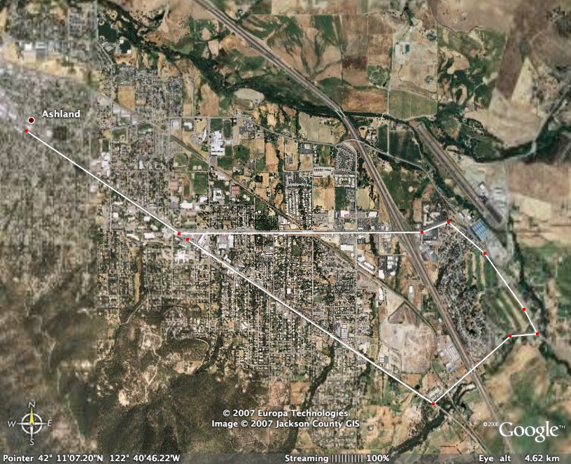
Create a 5K race for your community
(or Monmouth area).
Try to think of all aspects of setting
up the race course (i.e. room for spectators, staging area for runners/bikers/etc.,
interesting terrain, loop rather than out and back, etc.). Are there
nearby places to stay or camp. Where will you eat? Open Google Earth
and type in your location. Zoom in for details. Show street names
to virtually find your way around.
Under the Tools menu item, select “Measure”.
Next chose Kilometers as your measurement. The curser on the map will
switch to a small “square”. Position the curser where
you want to start your measurement. Keep clicking along the path and
watch your mileage grow. (Note: if you make a mistake, Control click
on your last entry to delete it.)
You can zoom in or out as well as move
up and down or sideways by using the navigation tools at the bottom
of the screen while measuring your course.
Zoom in or out to fill the screen with
your racecourse. Decide whether to show streets (if it isn’t
too much information). Save the image as
a .jpg. Title it something that you will remember. Open this image in Photoshop
and add a title, your name and any other info that seems appropriate.
Resize if needed to
print. Save as a .jpg file. Print a copy of the
course to turn in. Attach a Word file giving a brief description of
the location, the course, and any other considerations you deem appropriate.
You will turn in a printed version
of your map and a Word document.
Due at the beginning
of class during the week of February 12.
Example:
Office hours: Tuesday mornings: 9:00 - noon
Thursday mornigns: 9:00 - noon
Other times aby appointment
Also contact me through email at saxowsd@wou.edu
or denvygail@saxowsky.com